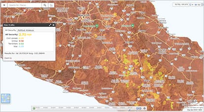
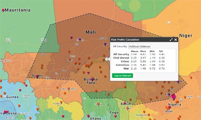
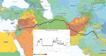
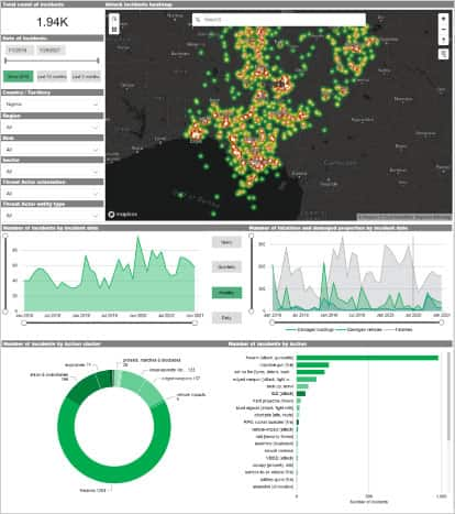
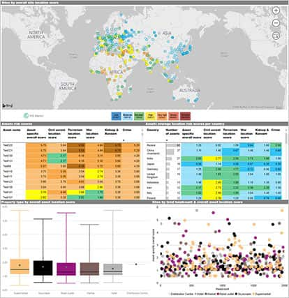
Geospatial Mapping: Visual Risk Assessment & Geospatial Analysis
{"items" : [
{"name":"facts","url":"","enabled":false,"desc":"","alt":"","mobdesc":"PDF","mobmsg":""},{"name":"login","url":"https://products.markit.com/home/login.jsp","enabled":true,"desc":"Product Login for existing customers","alt":"Login","large":true,"mobdesc":"Login","mobmsg":"Product Login for existing customers"},{"name":"sales","override":"","number":"[num]","enabled":true,"desc":"Call Sales [num]","proddesc":"[num]","alt":"Call Sales</br>[num]","mobdesc":"Sales","mobmsg":"Call Sales: [num]"}, {"name":"share","enabled":true,"desc":"<strong>Share</strong>","mobdesc":"Share","options":[ {"name":"facebook","url":"https://www.facebook.com/sharer.php?u=http%3a%2f%2fssl.ihsmarkit.com%2fmarketintelligence%2fen%2fmi%2fproducts%2fgeospatial-mapping-visual-risk-assessment-and-geospatial-analysis.html","enabled":true},{"name":"twitter","url":"https://twitter.com/intent/tweet?url=http%3a%2f%2fssl.ihsmarkit.com%2fmarketintelligence%2fen%2fmi%2fproducts%2fgeospatial-mapping-visual-risk-assessment-and-geospatial-analysis.html&text=Geospatial+Mapping%3a+Visual+Risk+Assessment+%26+Geospatial+Analysis+%7c+S%26P+Global","enabled":true},{"name":"linkedin","url":"https://www.linkedin.com/sharing/share-offsite/?url=http%3a%2f%2fssl.ihsmarkit.com%2fmarketintelligence%2fen%2fmi%2fproducts%2fgeospatial-mapping-visual-risk-assessment-and-geospatial-analysis.html","enabled":true},{"name":"email","url":"?subject=Geospatial Mapping: Visual Risk Assessment & Geospatial Analysis | S&P Global&body=http%3a%2f%2fssl.ihsmarkit.com%2fmarketintelligence%2fen%2fmi%2fproducts%2fgeospatial-mapping-visual-risk-assessment-and-geospatial-analysis.html","enabled":true},{"name":"whatsapp","url":"https://api.whatsapp.com/send?text=Geospatial+Mapping%3a+Visual+Risk+Assessment+%26+Geospatial+Analysis+%7c+S%26P+Global http%3a%2f%2fssl.ihsmarkit.com%2fmarketintelligence%2fen%2fmi%2fproducts%2fgeospatial-mapping-visual-risk-assessment-and-geospatial-analysis.html","enabled":true}]}, {"name":"rtt","enabled":true,"mobdesc":"Top"}
]}